U.S. 219, U.S. 460, Other Routes in Southwest Virginia
Using historical topo maps it is possible to get a pretty good idea of what roads went where -- in this case, the various routes of U.S. 219 (and later, U.S. 460) between Peterstown, West Virginia to Bluefield, West Virginia, via Princeton, West Virginia.
Click on the image for a larger image
(full quad in PDF)
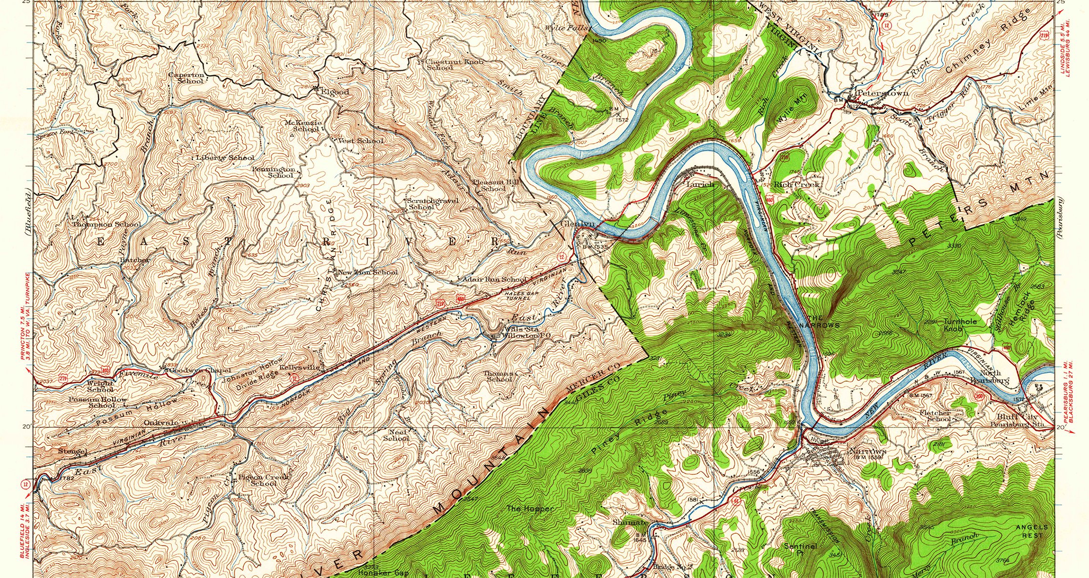
The 1932 Narrows quad shows WV 12 running south into Peterstown, where it intersects with U.S. 219. From Peterstown, U.S 219 continues southwest into Rich Creek, where it joins U.S. 460 running on the bluff above the New River from Narrows. The road loops around the bend in the river, again on the bluff above the Virginian Railway tracks and the river. After crossing the river at Glen Lyn and entering West Virginia, the road is tagged WV 12, U.S. 219, and U.S. 460. The road crosses Hale's Gap and drops into Kellysville (see http://www.brucebharper.info/nwrwy/kellysville/kellysville.html for info on how the road and railroad fit in here before the four-lane was built) and follows what is today WV 112 to Oakvale. At that point, WV 12 continues up the East River to Ingleside and Bluefield, while U.S. 219/460 head up Fivemile Creek to Goodwyn Chapel, which is today WV 3/5, Goodwins Chapel Rd. The topo map shows a relocation of part of the road, which today shows as Hatcher Rd., WV 219/3. The Narrows map ends at that point, but not without an interesting clue.
At the edge of the map, there is a split in the road, with one branch dropping south to Fivemile Creek and the main branch going northwest. This is the one with the continuation arrow in the margin pointing to "Princeton 7.5 mi. w.8 mi. to W. Va. Turnpike". When matched up with the Bluefield quad, there is a road up a creek hollow to Queen School, then continuing north before turning west to pass Johnson School and continue on to Princeton. There is no road shown up the creek on the Google map terrain view of the area, until one runs into WV 219/3, Halls Ridge Road. However, the WVDOT map of Mercer County (linked at the end) shows a "primitive road" up this hollow tagged WV 460/12.
Click on the image for a larger image
(full quad in PDF)
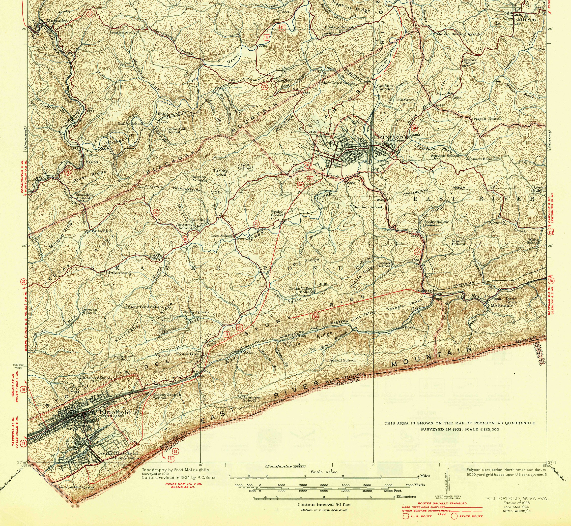
The Bluefield quad of 1926 (reprinted 1944, shown as 1924 on the historic map site) shows the road above, but it has U.S. 219 running along Fivemile Creek, on what is today WV 460/1, Hilltop Drive. Where today the four-lane makes a curve from northwest to west toward the Turnpike interchange, Halls Ridge Road continued straight across that area, showing up today on the south side of the highway as WV 460/8. Where the two roads meet is where U.S. 219 continued along Hilltop Dr. to cross just south of the original end of the West Virginia Turnpike, connecting with today's Oakvale Road. It continued west to a junction with WV 20 from the north.

Click on the image for a larger image
The maps from the 1960s give a pretty good idea of the state of the roads before the construction of four-lane U.S. 460 from the state line to Princeton (full versions are linked at the end).
Click on the image for a larger image
(full quad in PDF)
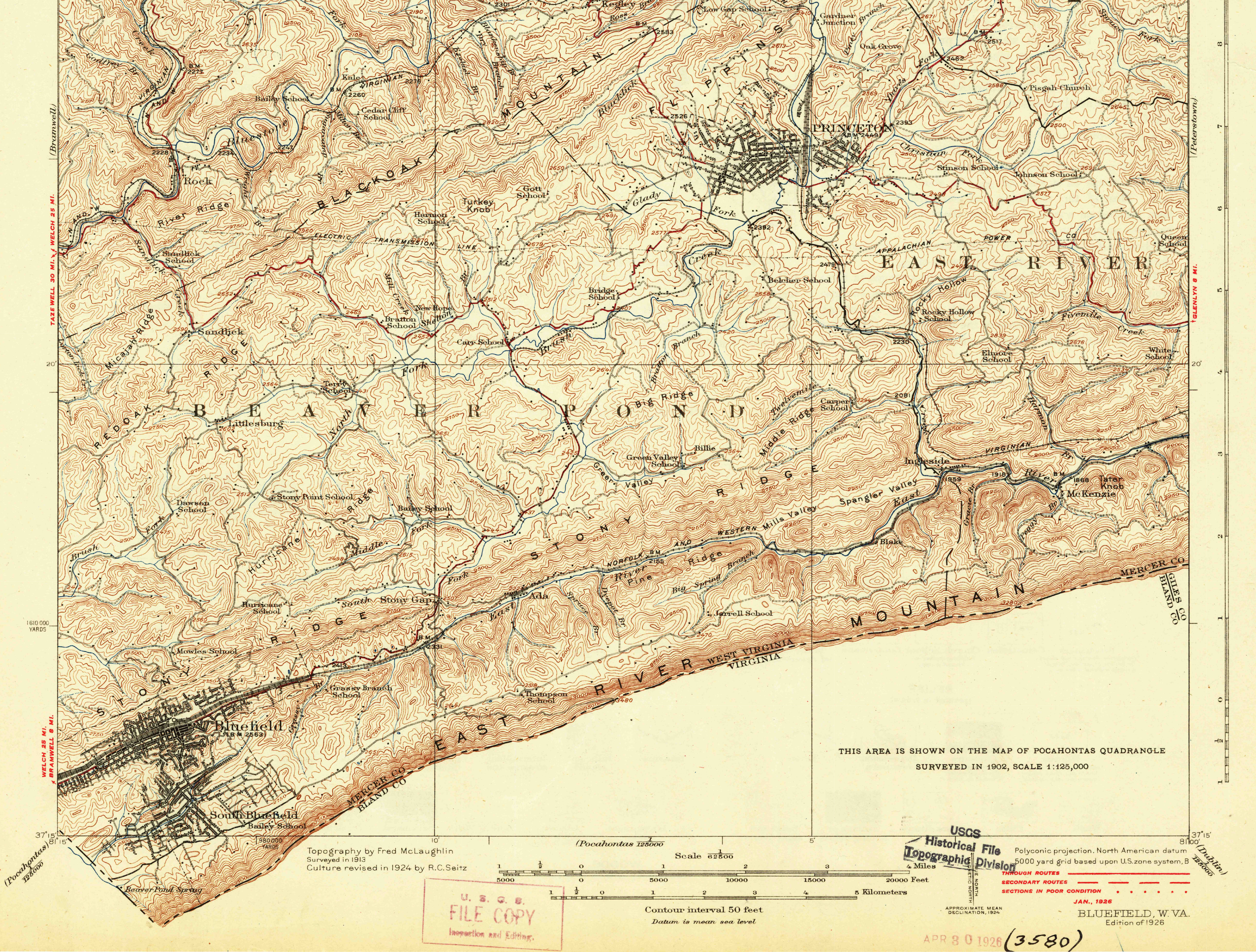
The 1926 Bluefield quad shows both roads swung southwest on Rogers St. to cross under the Virginia Railway to Brick St. The marking ends there, so there is no indication of what streets were followed to get across town. On the other side of town, U.S. 19 roughly follows what is today City View Heights Road and meandering around today U.S. 19, Courthouse Rd. until it reahced the intersection of Green Valley Rd. (Google)/Glenwood Park Rd. (USGS). At Maple Acres Rd., U.S. 19 turns south and follows that road to Green Valley, where is picks up roughly what today is WV 123. When 123 turns west, the original road followed what is now Mercer Mall Road to Stony Gap. On the other side of the gap, it continues on today's Old Princeton Road, crossing the Norfolk & Western tracks on a bridge to Virginia Ave. and following that street into downtown Bluefield.
From the junction at Glenwood Park Road and Old Bluefield Rd., the highway ran with the interurban tracks between Bluefield and Princeton. At that point, the tracks continued along Old Bluefield Road along Brush Creek, heading to downtown along S. Walker St.
On the 1926/1944 map, U.S. 219 runs into Princeton to Rogers St., jogs up WV 20, and both roads follow Thorn St. to cross the VGN yards, turns south for a block, then run into downtown on Mercer St. Multiple roads come together at the square then head north, west and south out of town. U.S. 19 and U.S. 21 head west on Honaker St., then up Beckley Road to Kegley and beyond. WV 20 heads west on W. Main St. then down New Hope Rd. U.S. 19/21 head south on S. Walker St. then jog to today's Airport Dr. There is a solid red line (apparently the "photorevision" of the day) that runs roughly along the route on the 1926 map to Old Bluefield Road, then heads cross country to Green Valley and Stony Gap. It is pretty close to the alignment of today's U.S. 19/460. After going through the gap, the road crosses the Norfolk & Western tracks and the East River, then continues on the south side of the tracks into downtown Bluefield. It also shows Grassy Branch Road heading to today's Cumberland Road along the base of East River Mountain. There is another red line heading up and across the mountain tagged U.S. 21 and U.S. 52 heading to Rocky Gap, Va. and Bland.
At the edge of the map, just past downtown Bluefield, U.S. 19 continues toward Tazewell.
The other interesting part of the map is to the east. Today's WV 112 is shown as WV 38 running along the East River to Ingleside. From Ingleside, a road follows the river and railroad tracks to Blake, then continues west to Big Spring Branch and heads up that hollow. That road today, on Google, is shown as WV 38/5 and continuing all the way up the river almost to Ada, emerging on WV 112 as Jug Neck Rd. In my experience, the road only goes as far and Blake and ends there; it doesn't go all the way through.
Back at Ingleside, a red line tagged WV 38 climbs up the ridge then continues straight along the top of the ridge ending short of the "new" U.S. 19/21. Where the road ended up was running through Mills Valley/Spangler Valley (where I-77 turns west as it works its way up to the tunnels at East River Mountain), then along the side of Stony Ridge. Also at Ingleside, WV 27 is shown running north in the creek bottom while the Virginian was up along the ridge as it climbed into Princeton. Road and tracks ran together to about where the present four-lane U.S. 460 is today, then WV 27 turned west along Glady Fork, then north into Princeton on today's WV 27/1.
-------
Here are the current PDFs of the various quads:
- Bluefield
- Bluefield 1962
- Narrows
- Oakvale
- Oakvale 1965
- Peterstown
- Princeton
- Princeton 1962
- Mercer County (WVDOT map)
-------
The USGS is your friend.
The on-line map store offers a selection of historical maps to download:
The historical map viewer has the capability to overlay historical maps on a current view of an area, with sliders to control transparency to see changes:
http://historicalmaps.arcgis.com/usgs/